
Stelvio Pass Road – History, Giro d’Italia & Cycling from Mals

Long before the first cyclist climbs the pass in spring, the road usually still lies hidden beneath metres of snow. Hairpin after hairpin it rises from Gomagoi, climbs past Trafoi towards the Franzenshöhe and then winds its way through the high-alpine landscape up to the pass. It was not originally built for travellers, but for a very different purpose.
The Stelvio Pass road was built in the early 19th century as a military route through a remote border region of the Habsburg Empire. Today it has become something entirely different. Cyclists from all across Europe come here to ride the famous 48 hairpin bends themselves. Professionals in the Giro d’Italia, ambitious amateurs – and sometimes simply curious travellers who want to experience what it feels like to ride a road that has remained almost unchanged in the landscape for more than two centuries.
Those who ride it quickly realise that the Stelvio is not an attraction in the usual sense. It is a road – and at the same time a piece of history you can climb.
From Imperial Military Route to Cycling Legend
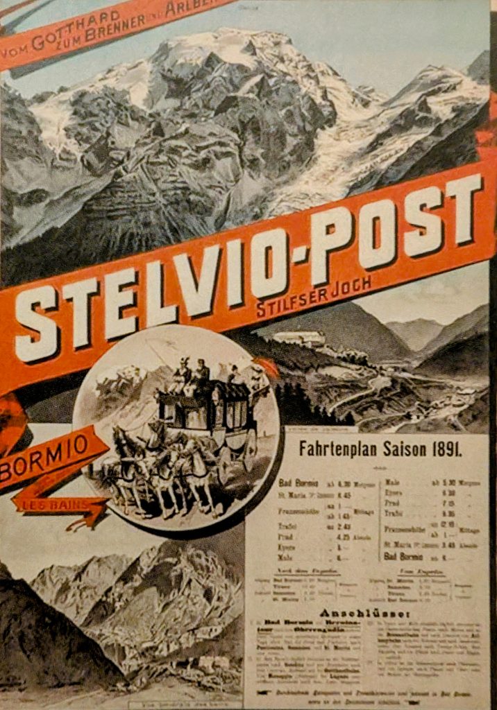
1825 wurde die Stilfserjochstraße eröffnet. Geplant unter Kaiser Franz I. von Österreich als strategische Verbindung zwischen Tirol und dem damaligen Lombardo-Venetien. Der Bau war kein romantisches Alpenprojekt, sondern ein militärisches Infrastrukturvorhaben. Truppen, Verwaltung und Postkutschen sollten schneller zwischen den Provinzen verkehren können.
In nur fünf Jahren entstand unter extremen Bedingungen eine Hochgebirgsstraße, deren Linienführung bis heute nahezu unverändert geblieben ist. Als die Straße eröffnet wurde, galt sie als technische Sensation. Kaum irgendwo sonst führte damals eine durchgehende Fahrstraße in solche Höhen. In den ersten Jahrzehnten waren es vor allem Postkutschen und Militärtransporte, die das Stilfserjoch nutzten. Die Fahrt über den Pass dauerte viele Stunden und hing stark vom Wetter ab. Selbst im Sommer konnten Schneefälle die Route blockieren.
Deshalb entstanden entlang der Strecke mehrere Straßenwärterhäuser. Ihre Aufgabe war schlicht: die Straße offen zu halten – Steine entfernen, Lawinen räumen, Schnee schaufeln. Manchmal gelang das nicht. Dann saßen Reisende – Beamte, Händler oder Soldaten – in Gasthäusern von Trafoi oder auf der Franzenshöhe fest und warteten, bis der Pass wieder befahrbar war.
2025 wurde das 200-jährige Bestehen der Straße unter anderem in Prad am Stilfserjoch gefeiert. Historische Umzüge erinnerten an Postkutschenzeiten, militärische Nutzung und an jene Phase im 20. Jahrhundert, als sich am Stilfserjoch auch das Sommerskifahren entwickelte – eine Besonderheit, die auf den Gletschern oberhalb des Passes bis heute möglich ist und vor allem von internationalen Skimannschaften zum Training genutzt wird. Was einst als Machtinstrument gebaut wurde, ist heute Teil einer ganz anderen Bewegung: Menschen fahren diese Straße freiwillig hinauf – aus eigener Kraft.
History and Landscape of the Stelvio Pass
At 2,757 metres, the Stelvio Pass is one of the highest paved mountain passes in the Alps.
The actual beginning of the Stelvio Pass road lies in Gomagoi – a small village at the entrance to the Trafoi Valley, often referred to as the “gateway to the Stelvio”. Shortly afterwards, the first of the 48 numbered hairpin bends already appears, climbing from here all the way up to the pass.
The road first leads to Trafoi. Today the village has become quiet, but around 1900 Trafoi was a fashionable alpine spa and tourist resort. Travellers from Vienna, Munich or Milan came here to experience the view of the Ortler – often still arriving by stagecoach along the pass road. The most famous son of the village is Gustav Thöni, one of the most successful alpine ski racers of the 1970s, Olympic champion and multiple overall World Cup winner.
Beyond Trafoi the real high-alpine ascent begins. The road continues upward towards the Franzenshöhe. Here the tree line gradually disappears and the landscape begins to change its character. Forests give way to rocky slopes and alpine meadows. Above everything rises the Ortler (3,905 m) with its glacier landscape in the Stelvio National Park.
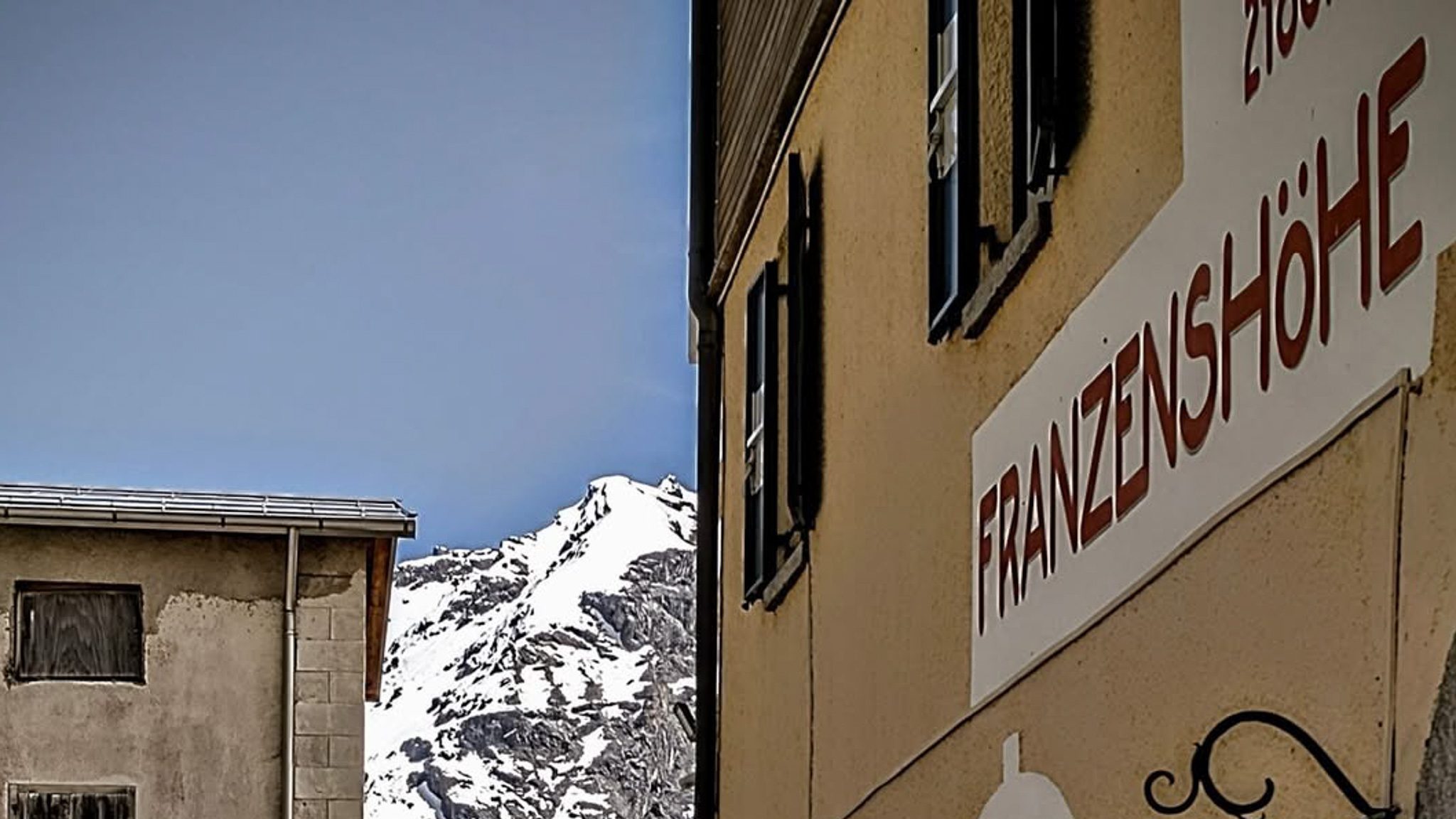
From the Franzenshöhe onward, the road runs fully through high-alpine terrain. The view opens wider, the air becomes cooler – and the road suddenly seems small between rock and sky.
Stelvio Pass & the Giro d’Italia – A Test of Alpine Cycling
Since the Giro d’Italia, the Stelvio Pass has been part of international cycling history. In 1953, Fausto Coppi launched his decisive attack here. Since then, the highest point of each Giro edition has been known as the “Cima Coppi”.
However, in cycling the Stelvio Pass is not known only for legendary victories.
A famous photograph from 1965 shows Aldo Moser carrying his bicycle through metre-high walls of snow. June. A Giro stage. And yet winter conditions. The image has become a symbol of this pass. Because on the Stelvio it is not only the riders’ legs that climb – the weather always rides along as well.
Several times the Giro had to change planned crossings at short notice or cancel them altogether, for example in 1988 or 2014. The Stelvio Pass may appear on the race route, but whether it can actually be ridden is often decided only by the snow. That is precisely why it remains a reference.
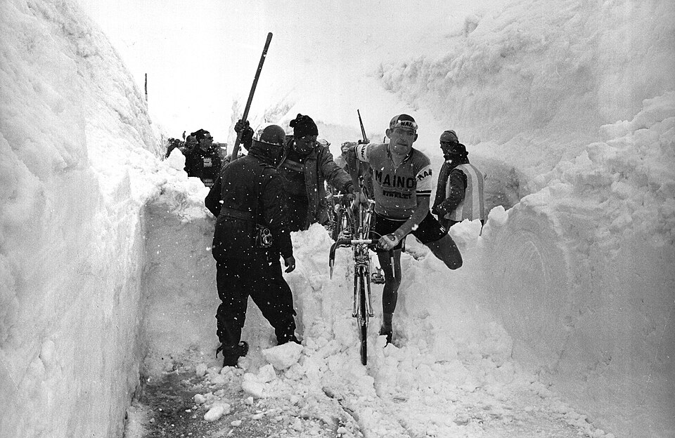
Aldo Moser at the Giro d’Italia in 1965 on the Stelvio Pass – one of the most famous scenes in cycling history.
Photo: Wikimedia Commons, license CC BY-SA 3.0.
Stelvio Pass Cycling – A Challenge for Amateur Riders
The pass is no longer reserved only for professional riders.
Once a year the road is completely closed to motor traffic. During the Stelvio Bike Day it belongs exclusively to cyclists. No engine noise, no traffic – just bicycles, breathing, and the steady rhythm of the hairpin bends.
But even outside this day, the pass attracts riders from all across Europe.
The 1,800 metres of elevation gain from Gomagoi require patience and careful pacing.
Whoever reaches the top has earned the climb – no matter how long it took.
That is exactly why the Stelvio Pass is now considered one of the most famous road cycling climbs in the Alps.
Road Cycling Tour from Mals – The FinKa as a Starting Point
From Mals in Upper Val Venosta, one of the most beautiful road cycling loops in the region begins almost effortlessly.
The first kilometres roll gently across the valley floor. The route passes through Glurns, alongside its fully preserved 16th-century town walls. Beyond Prad the climb begins – although the actual Stelvio Pass road starts only a few kilometres later in Gomagoi. From there the road winds hairpin after hairpin past Trafoi and the Franzenshöhe all the way up to the pass.
The tour does not necessarily end at the top. Many riders continue over the Umbrail Pass into the Val Müstair and return via Taufers im Münstertal. Around 90 kilometres and more than 2,000 metres of elevation gain connect two countries: Italy and Switzerland.
And at some point in the evening you find yourself back at the door of the FinKa. Then the same routine usually follows: room key, a shower, perhaps a beer in the Salone. Knowing that you will return here somehow makes the climb up the Stelvio a little more relaxed.
FinKa Tip: Cycling the Stelvio Pass
If you want to ride the Stelvio Pass starting from the FinKa, it is best to start early in the morning. At that time Val Venosta is usually still quiet, traffic is light and temperatures are more pleasant. The classic route begins in Mals, continues through Glurns and Prad to Gomagoi, where the actual Stelvio Pass road begins. From there the famous 48 hairpin bends lead all the way up to the pass at 2,757 metres.
Start early
The climb is long and during summer temperatures can rise even at high altitude.
Pace yourself
The first hairpins may seem moderate, but the pass is long. Riding at a steady rhythm helps save energy for the final kilometres.
Watch the weather
Even in summer conditions on the Stelvio can change quickly. A light wind jacket is almost always useful.
Stop at Franzenshöhe
From here the view opens towards the Ortler – for many riders this is the moment they realise how high they have already climbed.
Plan your return
A particularly beautiful loop continues over the Umbrail Pass into Val Müstair and returns via Taufers im Münstertal to Mals.
After around 90 kilometres and more than 2,000 metres of climbing the ride usually ends again at the door of the FinKa – where a long ascent eventually turns into a good story.
Stelvio Pass – Key Facts
- Elevation: 2,757 metres
- Hairpins (north side): 48
- Elevation gain from Gomagoi: approx. 1,800 metres
- Length of the climb: about 25 kilometres
- Road opening: usually May/June to October
- Special feature: highest point of the Giro d’Italia (“Cima Coppi”)
- Cycling event: Stelvio Bike Day (car-free day)
Conclusion – Why the Stelvio Pass Still Remains a Benchmark
The Stelvio Pass is many things at once:
A military road of the 19th century.
One of the most spectacular high-alpine routes in Europe.
A legend of the Giro d’Italia.
And a destination for road cyclists from across Europe.
For more than two hundred years this road has outlasted political systems, technological developments and generations of athletes. Its route has remained almost unchanged. What has changed is the reason why people climb it. In the past it was about controlling a mountain region. Today it is usually about something simpler:
to see whether you can make it to the top. Or – if we are honest – simply to make it safely back down again.
Frequently Asked Questions about the Stelvio Pass Road
How high is the Stelvio Pass?
The Stelvio Pass lies at 2,757 metres above sea level.
How many hairpin bends does the Stelvio Pass road have?
The northern ascent from Prad or Gomagoi includes 48 numbered hairpin bends.
How many metres of elevation are there from Gomagoi to the pass?
The climb covers around 1,800 metres of elevation gain.
Is the Stelvio Pass suitable for road cyclists?
Yes. The pass is considered one of the most famous road cycling climbs in the Alps.
When is the Stelvio Pass open?
Usually from late spring until autumn, depending on snow conditions and weather.
What does “Cima Coppi” mean?
The Cima Coppi refers to the highest point of a Giro d’Italia edition.
Are there car-free days on the Stelvio Pass?
Yes. During the Stelvio Bike Day the road is reserved exclusively for cyclists.
Which cycling loop is recommended from Mals?
The loop Mals – Stelvio Pass – Umbrail Pass – Val Müstair – Taufers covers about 90 km and more than 2,000 metres of elevation gain.
Experience the FinKa!
📩 Reservations & Room Booking: info@finka.it
📞 Phone: +39 0473 427040
🌐 www.finka.it
Winter. FinKa
Winter. FinKa “The snow hatches the landscape,” writes Lydija Tschukowskaja (Going Under, 1972). Here, the snow draws a softly falling curtain onto the wooden wall of the terraces and in front of the landscape. The view outward dissolves into the indistinct. The...
Von Ardara nach Killybegs
Als ich am Abend von Dublin aus in Ardara ankam und mein Cottage bezogen hatte, war klar: Jetzt sollte der Irland-Trip richtig beginnen. Und wo ginge das besser als in einem Pub. Ich steuerte direkt das The Corner House an. Ein paar Locals saßen am Tresen, im Kamin...
Dumpling Philosophy at FinKa Hostel: Authentic Upper Val Venosta Dumplings
The history of dumplings – from Hocheppan to the FinKa The oldest known depiction of South Tyrol’s most famous traditional dish can be found in a cycle of frescoes dating back to around 1200 in the small castle chapel of Hocheppan. Among biblical scenes, such as the...
Want to be part of this story?
www.finka.it